


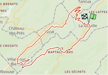
la mouille -villard sur bienne

XavierFaidix
User

Length
25 km

Max alt
973 m

Uphill gradient
825 m
Km-Effort
36 km

Min alt
501 m

Downhill gradient
825 m
Boucle
Yes
Creation date :
2025-07-23 09:26:02.341
Updated on :
2025-07-23 11:51:46.362
2h25
Difficulty : Medium

FREE GPS app for hiking
 SityTrail
IGN / Geographical institutes
SityTrail Plus
The world is yours!
About
Trail Mountain bike of 25 km to be discovered at Bourgogne-Franche-Comté, Jura, Hauts de Bienne. This trail is proposed by XavierFaidix.
Positioning
Country:
France
Region :
Bourgogne-Franche-Comté
Department/Province :
Jura
Municipality :
Hauts de Bienne
Location:
La Mouille
Start:(Dec)
Start:(UTM)
728710 ; 5154513 (31T) N.
Comments